MTB3 - Percorso Castellana - Polizzi - Madonna dell'Alto

MTB3 - Percorso Castellana - Polizzi - Madonna dell'Alto
Approach
From Castellana Sicula you reach Nociazzi village and after crossing the town continue to the picnic area just above Petrolito mill, just after the junction to the right towards the "Santuario Madonna dell'Alto".
Trail
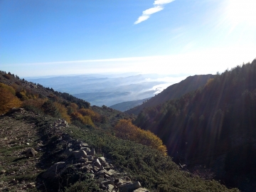
The MTB3 trail begins at the fountain next to the picnic area. To the right of a private property access gate at 1040 meters above sea level, starts a forest track that climbs up and, with a series of bends, arrives to a rural farm located at the edge of the pine forest. Once crossed a pass you continue to climb, always on a dirt track, through a series of curves within a sparse pine forest which has many areas without pines, destroyed due to previous years fires, and you will arrive at Rocche del Pomo slopes. The track runs along the slopes following their orographic profile and outflanking them enters the valley "San Salvatore". The track starts climbing along the river left bank, passes a crossroad on the left descending towards a spring, it passes a fence and it keeps climbing to the right, and arrives to the "Sorgente del Pomo", where it is not possible to reach the water. Once passed another fence continue climbing along the edge of State property reforestation area, pass a crossroad that leads to the great stables on the left, and with another sudden rise and a series of bends you come to a gate where a sign indicates the access to the Park "A" area. It goes up now into the beech forest, at 1640 meters above sea level, cross the river head, and with a series of curves, after little more than a kilometre, it reaches the junction with the dirt road, which comes from Piano Grande. Continue on this slightly uphill inside the beech woods, and at first you arrive to the Madonna dell'Alto fountain, then to the glade where the "Sentiero della Pace" and the "Sentiero dei Pellegrini" arrive and from where it begins the final ascent to the sanctuary, approximately 500 meters long, located at 1827 meters above sea level, one of the most elevated in Italy, which can be reached after leaving to the right a dirt track that goes down to Petralia Sottana / Polizzi Generosa.
Alternative tracks
After leaving the state road after 4.5 km, there are two same length variants (around 3 km): one has a harder off-road path, the other leads to the final climb through an asphalt road. From here, the bottom is a dirt slow and often sandy road. But every uphill kilometer reveals a breathtaking landscape: half Sicily can be seen from this astonishing place.
final ascent, approximately 500 m long, to the Santuario Madonna dell'Alto, one of the highest in Italy at 1.827 m, where you arrive passing up on the right the dirt track going down to Petralia Sottana/ Polizzi Generosa.