560 - Sentiero Collesano - Isnello

560 - Sentiero Collesano - Isnello
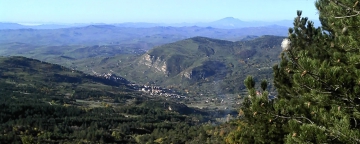
Taking the sp9 bis street from Collesano towards Scillato, we meet on the left an initially paved road that climbs towards south-east. Proceeding, while the track becomes a steep path (not always visible), it climbs between the Roccella River course and the Bosco Volpignano holly wood that cloaks Mount Cucullo northern slope (1416 meters above sea level).
Shortly after we reach Case Volpignano, a manor farm located in a wonderful location, on a plateau surrounded by dense vegetation and opened to the north. It is a big and articulate complex dating back to the early XX century, one of the most interesting in Madonie area. Outside, the manor farm presents an elegant and simple façade while inside it is composed by a large squared paved courtyard, from where you can reach the other rooms. Inside the building is also located a chapel, whose access is outside of the courtyard.
Then you reach the Munciarrati junction, which is located along the boundary perimeter of the "Querceto Isnello". It is one of Madonie largest and most intact forestal areas, a place where very old and massive Downy Oak, Hollies, Corks and a rich undergrowth forms a dense and impenetrable wall that, followed upstream by the superb "Faggeta Madonia", it extends up to Pizzo Carbonara. The views that can be admired in the Madonie are large and beautiful: starting from north-east after Isnello and Pollina valley, to south-east over the lush Montaspro valley, crowned by Pizzo Antenna crests, and also toward the west coast after Collesano, with Termini Imerese Gulf.
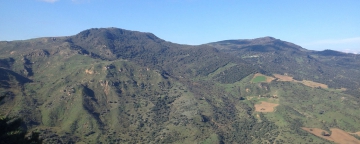
After the junction on road 54, you arrive at Pizzo Dipilo slopes, mostly uncovered and composed by steep and greyish rocks of limestone and dolomite origin, that shows clear traces of karst phenomena, whose best-known examples are the Grotta dei Panni located at 1190 meters above sea level and the Grotta dell'Appesa located on the terraces at 900 mt. of elevation. Pizzo Dipilo, 1,385 meters above sea level, is a difficult and challenging hike due to the valleys width and to the lack of marked accesses and paths. Its commonly inhospitable appearance is still very different during spring, when narcissi and euphorbia bloom with their bright colours.